


Voting District 1471618000004, St. Clair County, Michigan
About
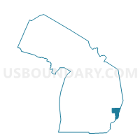
Outline

Summary
| Unique Area Identifier | 599421 |
| Name | Voting District 1471618000004 |
| County | St. Clair County |
| State | Michigan |
| Area (square miles) | 19.46 |
| Land Area (square miles) | 18.86 |
| Water Area (square miles) | 0.60 |
| % of Land Area | 96.90 |
| % of Water Area | 3.10 |
| Latitude of the Internal Point | 42.58020860 |
| Longtitude of the Internal Point | -82.61662010 |
Maps


Graphs
Select a template below for downloading or customizing gragh for Voting District 1471618000004, St. Clair County, Michigan


Neighbors
Neighoring Voting District (by Name) Neighboring Voting District on the Map
- Voting District 1470118000002, St. Clair County, MI
- Voting District 1471618000005, St. Clair County, MI
- Voting Districts not defined, St. Clair County, MI